
Proposal: Land Resources Information System
Project components and outcomes
Component 1: Strengthening policy, regulatory and institutional frameworks for sustainable land management:
Outcome 1: Enabling institutional policy and regulatory frameworks for SLM established and operational in accordance with participatory land use development (PLUD) principles
Output 1.4: Establishment of a new coordination and information sharing platform among the stakeholders
Output 1.5: Degraded agricultural lands in the project areas in the central highlands classified and mapped
Component 2: Implementation of the identified land restoration technologies in the affected areas of the three districts through a participatory process
Outcome 2: Appropriate technologies for rehabilitation of degraded lands demonstrated and scaled up by strengthened networks of training and extension institutions
Output 2.3: SLM training programme developed and implemented
Component 4: Knowledge management, awareness raising and dissemination of best practices
Outcome 4: Enhanced national knowledge base for sustainable land management and project implementation based on adaptive results-based management
Output 4.3: SLM good practice guidelines developed and disseminated
1. Introduction
The evidence based decision-making process is highly important to keep the balance between economic development and environmental management. Reliable, up-to-date, easily accessible LandResources Information System (LRIS) to strengthen Sustainable Land Management (SLM) coordination, isextremely useful to many stakeholders in the country for land planning, public programs implementation, environmental protection, resource management, and so forth. There are different agencies that involve in different kinds of data generation. It is not only difficult to access such data by the public and the decision-makers but also they are not compiled and presented in a way that are readily used for decision making. This means evidence-baseddecision-making is not being adopted in all level of development for sustainability. The stakeholders in the relevant sectorsagree that the situation must be improved. Data gaps and duplication of data should be avoided. Up-to-date information, fast and easy access is present day model. There is a critical need to progress with sustainable development which safeguard the environment and social values. At present, there are few government agencies, such as Survey Department, Natural Resources Management Centre –NRMC, Land Use Policy Planning Department,etc. maintain spatial data websites independently. Use of such data without integration is not possible for decision-makers and publicto facilitate the planning process. Consequently, the data are not meaningful for the users. Therefore, evidence baseddecision-making should be strengthenedthroughan integrated spatial data portal with other information to address data gaps, avoid data duplication and integrated availability of required information for sustainable land management.
2. Objectives
The roles of LRIS is to provide functional support in knowledge management and as act as decision support systems related to land management. Hence, LRIS need to maintain several data and information related to status of land resources, land degradation, and SLM practices suitable for various land degradation types. As any information system, LRIS has its own ecosystem consisting data, hardware, software/procedure, people, and network.
In the project’s context, several agencies are involved in land management related activities producing different types of relevant data for the RDAL project. The proposed RDAL LRIS builds on the strength of these agencies as stakeholders as proposed in Figure 1.
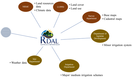
Figure 1: Proposed RDAL LRIS framework.
As mentioned above the database and analyzed maps related to status of land degradation and relevant SLM practices are one of the major information that a LRIS will contain and since there are no such data/information available for project area which are appropriate, the following tasks as objectives are proposed to complete.
- To conduct subnational level assessment of land degradation (LD) and sustainable land management practices (SLM)
- To select priority landscape and conduct local level assessment of LD and SLM
- To establish an ICT-based knowledge management platform for informed decision making
a. review of available data, identify data gaps, and determine data needs for a SLM information system that addresses Land Degradation Assessment in Dry Lands (LADA) recommendations;
b. create a web-based user.
- This will include preparation of Land Use System map based on available secondary data, and classify types, extent and severity of land degradation, document major SLM practices for the project areas in the central highlands
- This will include field data collection to prepare detail land degradation maps and document SLM practices for different landscape and land degradation types. Both assessments will involve all the stakeholders in the area
- This web-based platform will contain all original and analyzed data, where stakeholders and users can explore and visualize the type, severity, trend of land degradation, and recommended SLM practices for different land degradation along with other RDAL project outputs. The website will also house all outputs of RDAL.
c. disseminate information and increase stakeholders’ and public awareness on the issues of land degradation and the benefits of SLM through project website.
3. Outcome
The general outcome will be the establishment of LRIS for informed decision making useful for land users and stakeholders. LRIS will also help in mainstreaming as the relevant line agencies involved in SLM will have better understanding of land degradation issues and opportunity for addressing them from their own capacity.
The following outputs will be obtained from in course of establishing LRIS.
Output 1Degraded agricultural lands in the project areas in the central highlands classified and mapped
Natural Resources Management Centre (NRMC), Land Use Policy Planning Department (LUPPD) together with extension agents and local land users will classify and map the land in the participating districts according to level of land degradation. Based on this, maps of land degradation extent and severity will be produced and disseminated to the extension services and other concerned stakeholders. Where feasible, maps will also be produced on SLM best practices using the World Overview of Conservation Approaches and Technologies (WOCAT/LADA) methodology adopted by the United Nations Convention to Combat Desertification (UNCCD).
Activity 1.1: Prepare LUS map with major land degradation types and SLM practices
Activity 1.2: Conduct local level land degradation assessment by involving stakeholders in a training workshop
Output 2: A new coordination and information sharing platform among the stakeholders established under the auspices of the Ministry of Mahaweli Development and Environment (MoMDE), in its capacity as the UNCCD focal point of Sri Lanka.
The information platform is available to decision-makers in a suitable format, to strengthen SLM coordination. The Technical Coordination Committee (TCC) on agriculture-related activities proposed under the United Nations Convention to Combat Desertification – National Action Plan (UNCCD NAP)was established in Sri Lanka and made operational by Ministry of Mahaweli Development and Environment (MOMD&E). The TCC will patronage the activity.
Activity 2.1: Establishment of TCC on LD and SLM-related activities under the UNCCD NAP who will overlook the LRIS coordination and management
Activity 2.2: Establishment of ICT-based SLM coordination and information sharing platform
Activity 2.3: Training on ICT-based SLM coordination and information sharing platform to stakeholders
Output 3: Public awareness is increased on the issues of land degradation and the benefits of SLM through project website.
The major purpose is to create awareness of general public through factual information so that there is concerted efforts in arresting the land degradation by adopting best practices of SLM.
Activity 3.1: Establishment of Project website
Activity 3.2: Capacity building and development of awareness raising of local land users and staff in using web-based application
4. Methodology
The LRISwill bedesigned with the engagement of initial key stakeholders in the sector, and they are Natural Resources Management Centre (NRMC), Land Use Policy Planning Department (LUPPD), Department of Agrarian Development (DAD), Survey Department (SD), Irrigation Department (ID), and Land Commissioner General’s Department (LCGD).
A Technical Working Group chaired by NRMCand members from above stakeholders will provide technical guidance for successful implementation of the activity.
The existing spatial and non-spatial data will be reviewed, and data gaps will be identified to meet Land Degradation Assessmentin Drylands (LADA) recommendations on SLM related data.
The Information system is to be developed should be considered to be useful at GNdivision level for planning but it largely depends upon the resolution of available input data needed to prepare LUS and map out land degradation. Such information should preferably also be useful at parcel level by superimposing the parcel level boundaries parallel to SD cadastral mapping if relatively large resolution LUS map can be prepared. The list of spatial and non-spatial datathat could be considered for LRISare presented in the annex - 1.
Earlier during 2012-2013, land degradation data are completed for Kandy, Nuwara Eliya and Matale Districts using LADA-QM approach(annex -2). This will be reviewed for possibility of use in particular to its resolution and adequacy of information for intended LRIS.
LRIS framework – will be designed with the consultation of key stakeholders. Initial Stakeholders consultation in April 2019 has agreed to use available platform developed by Information Communication Technology Agency (ICTA) for National Spatial Data Infrastructure initiative.This will also be helpful to publicize LRISintegrating into national data infrastructure.
LRIS will focus the data for eight micro watershedsin the project area from where LUPPD collect data. Based on user comments and requests,the system architecture will be fine-tuned to meet the user requirements. The other relevant stakeholders’ engagement is promoted to expand the LRIS. The stakeholders will sign a memorandum of understanding (MOU) followed by an agreement on data collection, sharing, data update and maintenance addressing the sustainability of the LRIS system. The training and capacity building programs for the divisional, district and national level officers of stake holder agencies will be conducted to make the awareness on using and updating LRIS system.
As there will be independent project website hosting all project information and outputs, this will allow access the LRIS. The Land Resources Division of the Ministry of Mahaweli Development& Environment extend coordination support to establish, maintain and upgrade the LRIS and project website as well.
LRIS implementation mechanism is presented in Figure 2 and Time frame in Table 1.
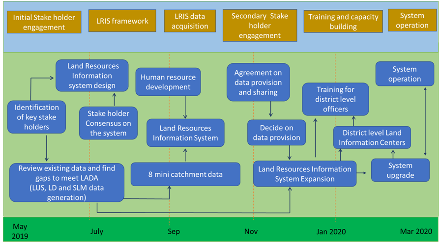
Figure: 2 RDAL LRIS implementation mechanism
Time frame
|
Output |
Activity |
2019 |
2020 |
||||||
|
Oct |
Nov |
Dec |
Jan |
Feb |
Mar |
Apr |
May |
||
|
Proposal |
Proposal technically cleared |
|
|
|
|
|
|
|
|
|
Output 1: Degraded agricultural lands in the project areas in the central highlands classified and mapped |
Activity 1.1: Prepare LUS map with major land degradation types and SLM practices |
|
|
|
|
|
|
|
|
|
Activity 1.2: Conduct local level land degradation assessment by involving stakeholders in a training workshop |
|
|
|
|
|
|
|
|
|
|
Output 2: A new coordination and information sharing platform among the stakeholders established. |
Activity 2.1: Establishment of TCC on LD and SLM-related activities under the UNCCD NAP that will overlook the LRIS coordination and management |
|
|
|
|
|
|
|
|
|
2.2: Establishment of ICT-based SLM coordination and information sharing platform |
|
|
|
|
|
|
|
|
|
|
2.3: Training on ICT-based SLM coordination and information sharing platform to stakeholders |
|
|
|
|
|
|
|
|
|
|
Output 3: Public awareness increased on the issues of land degradation and the benefits of SLM through project web site |
Activity 1: Establishment of Project website |
|
|
|
|
|
|
|
|
|
Activity 2: Capacity building and development of awareness raising strategy through the web based application |
|
|
|
|
|
|
|
|
|
Annex – 1
Primary Spatial Database Elements
|
Element |
Source |
|
Elevation |
SD / RS DEM models |
|
Slope |
SD / RS DEM models |
|
Crop suitability |
NRMC/ DOA / DOEA |
|
Land use |
LUPPD |
|
Land cover |
LUPPD |
|
Soil type, depth, texture etc., for associations/ series/ family etc., |
NRMC |
|
Drainage |
ID/ NRMC/ DAD |
|
Irrigation and drainage |
SD/ ID/ DAD |
|
Elevation contours / spot heights in meters |
SD / RS digital elevation model |
|
Watershed hierarchy polygons |
DAD |
|
Land degradation |
NRMC / LUPPD |
|
Hot spots - land and water constrains to sustainable agriculture |
NRMC/ LUPPD |
|
Agro ecological regions |
NRMC |
|
Natural hazards such as fire, drought, flood, areas |
DMC |
|
Administrative boundaries (provincial / district / DS / GN) |
SD |
|
Forest |
FD |
|
Roads |
SD |
|
Rail net work |
SD |
|
Rainfall / temperature observation locations |
MD / NRMC |
|
Rainfall / temperature data (minimum / maximum / average) |
MD / NRMC |
|
Location references |
SD |
Primary Non -Spatial Database Elements
|
Demographic data - most of the data available with DS offices - an example can be seen: http://www.ruwanwella.ds.gov.lk/images/downloads/sampath_2017.pdf |
Department of Census and Statistics |
Agency names and abbreviations:
|
Meteorological Department |
MD |
|
Department of Agrarian Development |
DAD |
|
Department of Agriculture |
DOA |
|
Survey Department |
SD |
|
Department of Export Agriculture |
DOEA |
|
Department of Forest Conservation |
FD |
|
Department of Irrigation |
ID |
|
Department of Land Commissioner General's |
DLC |
|
Department of Wildlife Conservation |
Wildlife |
|
Department of Land Use Policy Planning |
LUPPD |
|
Natural Resources Management Centre |
NRMC |
|
Divisional Secretary |
DS |
|
Land Reforms Commission |
LRC |
|
Disaster Management Centre |
DMC |
|
Ministry of Mahaweli Development and Environment |
(MOMDE) |